A four-storey mixed-use development on Bridge Street hit an unexpected snag last season: the preliminary desktop study classified the site as Class C, but the underlying Moutere Gravel formation in that pocket of Nelson was stiffer than anyone assumed. A single MASW survey line across the car park footprint revealed a VS30 of 480 m/s, bumping the site to Class B and saving the structural team over $120,000 in unnecessary foundation upgrades. That is the kind of clarity a well-executed shear wave velocity profile brings to a project. Nelson's terrain shifts dramatically within a few hundred metres—from dense gravels near the Maitai River to softer alluvial silts toward Stoke—and assuming uniformity is a costly gamble. We run active-source MASW with 24-channel geophone spreads tied to NZS 1170.5 site classification requirements, delivering VS30 values that hold up under peer review from council and independent engineers. The data integrates directly with seismic microzonation studies when larger precinct-scale assessments are required, and it pairs logically with CPT sounding to ground-truth stratigraphic boundaries across the profile.
A VS30 shift from 280 m/s to 410 m/s changes the seismic design category—and that single number can redirect a hundred thousand dollars of reinforcement steel.
Service characteristics in Nelson
Critical ground factors in Nelson
The most expensive mistake we see in Nelson is a designer accepting a default Class D assumption from the NZS 1170.5 table 3.1 without ever verifying it with a velocity measurement. The table defaults to Class D for 'unknown' soil profiles, which carries a higher design base shear coefficient and cascades into heavier structural members, larger pile groups, and stiffer lateral systems. On a recent subdivision above Atawhai Drive, a developer commissioned MASW on three lots originally classified as Class D by a desk study; two came back as Class C with VS30 above 220 m/s, and one hit Class B on Moutere Gravel at shallow depth. The total saving across retaining walls and foundation concrete exceeded $90,000. Equally risky is running a single survey line on a site with known lateral variability—the Maitai floodplain near Riverside Pool can swing from dense gravel to liquefiable silt within the footprint of one building, and a single VS30 measurement misrepresents the hazard. We always recommend at least two orthogonal spreads on sites larger than 400 m² to capture that variation.
Our services
MASW surveys in Nelson often form part of a broader site investigation package. The two services below are the most frequent companions when we work on projects from the Port Hills to Richmond.
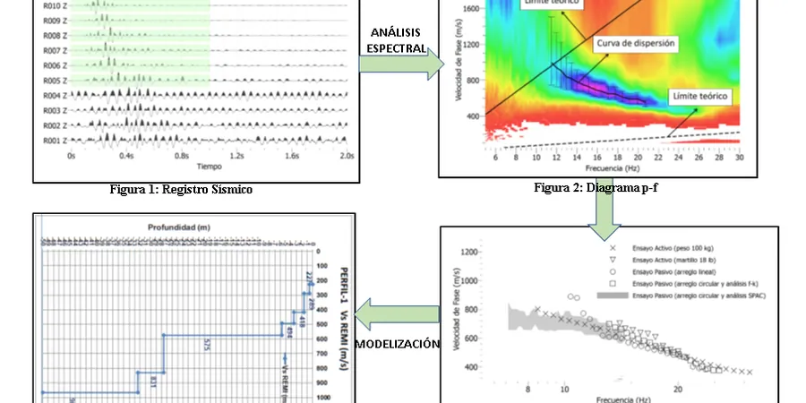
VS30 Site Classification Package
A complete MASW survey with NZS 1170.5-compliant reporting. Includes field acquisition with calibrated 4.5 Hz geophones, manual dispersion curve picking, 1D shear wave velocity inversion, and a formal site class letter signed by a Chartered Professional Engineer. Suitable for building consent submissions, foundation optimisation, and seismic hazard reduction across Nelson's mixed alluvial and hillside geology.
Combined MASW + CPT Ground Model
Pairing shear wave velocity profiles with cone penetration testing to build a high-confidence stratigraphic model. CPT provides continuous tip resistance and friction ratio data; MASW delivers the dynamic small-strain stiffness. Together they resolve the Vs–qc correlation for the specific Nelson formation, reducing uncertainty in liquefaction triggering analysis and site-response modelling.
Frequently asked questions
What does a MASW survey cost for a standard residential section in Nelson?
For a typical 400 to 800 m² residential lot, budget between NZ$2,770 and NZ$5,930 depending on access conditions, number of survey spreads required, and turnaround time. A single-line survey on flat ground with good access falls toward the lower end; sites with slope, dense vegetation, or the need for multiple orthogonal spreads to capture lateral variability push toward the upper range. The quote always includes field acquisition, processing, and a signed site classification report.
How does MASW compare to downhole or crosshole seismic testing?
MASW is non-invasive and does not require boreholes, which eliminates drilling costs and access issues on congested sites. The trade-off is resolution: crosshole testing delivers a higher-resolution Vs profile between two boreholes, making it preferable for critical infrastructure where centimetre-scale layering matters. For site classification per NZS 1170.5, MASW provides VS30 accuracy within ±10-15% of downhole measurements when processed correctly, which is well within the code's acceptance criteria for Class A through E determination.
How long does it take to get results after the field survey?
Standard reporting turnaround is five to seven working days. The processing sequence involves dispersion curve extraction, multi-mode inversion, and reconciliation with any existing borehole or CPT data from the site. Expedited three-day reporting is available for projects on tight consenting timelines—just mention it when booking the survey.