Nelson sits on a complex mix of Moutere Gravel, Port Hills loess, and Holocene alluvium from the Maitai and Waimea rivers. The 2022 NZ Seismic Hazard Model revision pushed median PGA values higher across the top of the South Island, and sites on deep gravel near Stoke can amplify short-period motion differently than the weathered argillite ridges in Atawhai. A site-specific seismic microzonation study resolves those contrasts into mappable Vs30 and site period layers, providing the ground-motion input for NZS 3404 analysis without relying on generic code spectra that often over- or underestimate the local response. Where gravel thickness exceeds 30 m, we often combine the microzonation survey with a MASW profile to capture shear-wave velocity to bedrock, and a seismic refraction line to constrain the lateral extent of buried paleochannels before finalising the site class boundaries.
Site class boundaries often shift by half a category once HVSR peaks are incorporated — the difference between C and D can move a foundation design from shallow pads to piles.
Service characteristics in Nelson
Critical ground factors in Nelson
A three-storey commercial building on Rutherford Street was originally scoped for shallow footings on the assumption of Class C gravel. A 24-hour passive array recorded a clear HVSR peak at 0.7 s, corresponding to a soft layer at 12–14 m depth that site investigation logs had missed between SPT intervals. The resulting site period pushed the eastern half of the lot into Class D, increasing the design base shear by roughly 25 % under NZS 1170.5. Without the microzonation survey, the structural engineer would have signed off on a lateral system calibrated to the wrong spectral shape. In the Nelson region, where Quaternary gravels often drape irregular bedrock topography, relying on a single borehole to assign site class across an entire parcel is a gamble that microzonation eliminates by mapping the subsurface in plan view.
Our services
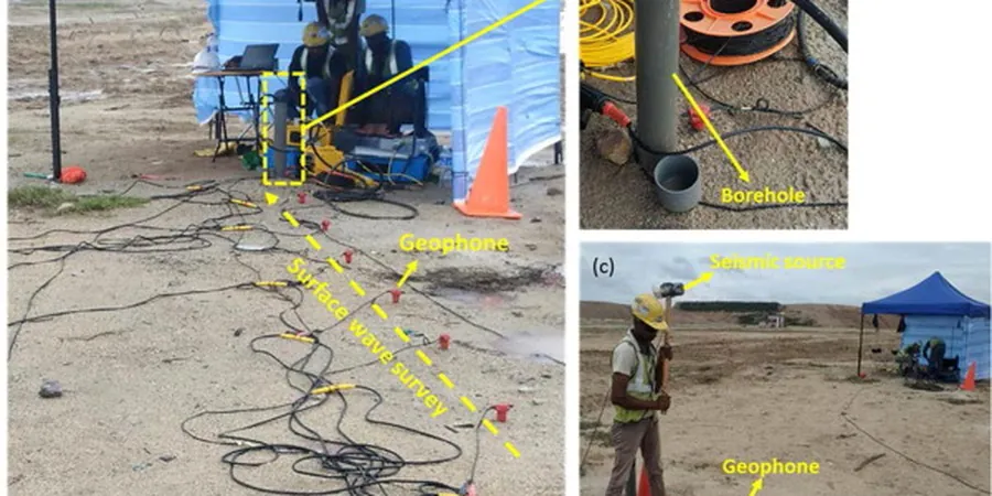
Microzonation work in Nelson usually requires a package of complementary geophysical and intrusive techniques to meet council consent requirements and give the structural engineer a defensible site class map.
Multi-method Vs30 and site class mapping
Combined active MASW, passive MAM, and single-station HVSR surveys across the full footprint, processed through joint inversion to produce Vs30 contours, site period maps, and amplification spectra referenced to the 2022 NSHM. Deliverables include GIS-ready shapefiles and a technical memo signed by a CPEng geotechnical engineer.
Borehole-calibrated microzonation for subdivision consent
Integrated workflow where CPT or SPT logs provide layer boundaries and material type, while surface-wave and downhole Vs measurements supply the velocity model. The calibrated profiles tie directly to NZGS Module 4 requirements and support resource consent applications with the Tasman District Council.
Frequently asked questions
How does the 2022 NSHM update affect site class determination in Nelson?
The 2022 National Seismic Hazard Model increased the median spectral acceleration values for the Nelson region, particularly at short periods (0.2–0.4 s). While the site classification framework in NZS 1170.5 remains unchanged, the higher reference rock motion makes the distinction between Class C and D more consequential because the amplification factors apply to a larger base value. Sites that previously sat near the C/D boundary may now require a microzonation survey to demonstrate compliance, since the cost of over-classifying a site has increased with the revised hazard curves.
What is the typical cost range for a seismic microzonation study on a Nelson commercial site?
For a standard commercial parcel of 2,000 to 5,000 m², the cost typically falls between NZ$8,030 and NZ$25,570 depending on the number of array positions, the depth to bedrock, and whether passive MAM recordings are required overnight. Smaller residential lots with a single array line may be priced at the lower end, while larger subdivisions that need multiple transects and a GIS deliverables package run toward the upper bound.
Can microzonation replace deep boreholes for site class assignment?
Microzonation does not replace boreholes for strength and settlement parameters, but it provides far denser spatial coverage of shear-wave velocity than drilling alone. The NZGS Module 4 guidelines accept Vs profiles from surface-wave methods provided they are calibrated against at least one point of ground truth — usually a CPT or SPT log. The combination yields a site class map with continuous coverage that a grid of boreholes cannot match on the same budget.